
Start an intelligence studies degree at American Military University. |
By Kurt Binversie, Faculty Member, Intelligence Studies at American Military University
During the past several weeks, most of the news coverage has shifted from national political campaigns, Major League Baseball spring training, and ongoing U.S. tensions with Iran to the emerging international spread of novel coronavirus, known specifically as COVID-19.
[Listen to the Podcast: Coronavirus in the US: Social Distancing and Educating the Public in a Time of Crisis]
At the time of publication, there are 99,624 confirmed cases of COVID-19 worldwide, according to the World Health Organization (WHO). The rapid spread of this virus has caused not only global healthcare concerns, but has also had significant economic implications as stock markets have suffered double digit declines.
As we continue to learn more about the coronavirus and its transmission, local, state and national governments around the world are taking measures to be prepared for an outbreak in their jurisdictions. Many government officials, emergency managers, business leaders, and even members of the public are turning to geospatial information systems (GIS) to monitor the spread of this disease in real-time.
Using GIS Platforms to Track the Spread of Coronavirus
In previous articles, I have focused on the benefits of using GIS for sharing real-time data during natural disasters such as hurricane and wildfire relief and recovery efforts. This technology can also be very useful to monitor this emerging healthcare crisis, help officials track cases of the coronavirus in real-time, as well as potentially predict future outbreaks. It’s important to remember when using these GIS platforms that the technology is only as good as the data reported from various sources.
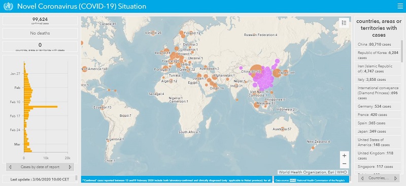
World Health Organization
The WHO provides a situational dashboard of the novel coronavirus updated every 15 minutes. This site provides a great, one-stop snapshot for officials looking for a breakdown of coronavirus by country and date in an easy-to-view visual dashboard. While the WHO is a great source of information, it’s not the only site providing real-time data about the coronavirus. Below is the WHO operational dashboard:
Environmental Systems Research Institute
One of the best ways to view real-time information on coronavirus is through the Environmental Systems Research Institute (ESRI) ESRI Disaster Response Program. This website includes in-depth information spread across various operational dashboards, in real-time.
An operational dashboard allows the user to view geographic information to help monitor events or activities. Furthermore, the dashboards are designed to display multiple visualizations that work together on a single screen and offer a comprehensive and engaging view of data to provide key insight for at-a-glance decision making, according to the ESRI site.
The ESRI Disaster Response Program has taken information on the coronavirus a step further to include various global, regional and featured datasets related to the virus and public information. It also includes direct links to the World Health Organization, Centers for Disease Control and Prevention (CDC) and European Centre for Disease Prevention and Control (ECDC).
Center for Systems Science and Engineering at JHU
In addition, the Center for Systems Science and Engineering at Johns Hopkins University (JHU) maintains its own GIS operational dashboard that maps the coronavirus breakout in real-time for similar use as well. Below is a snapshot in time of the operational dashboard that they create.
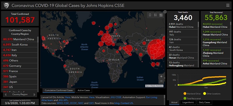
JHU also provides details modeling the spread of the coronavirus based on a set of attributes. While there are too many attributes to discuss here, many of the factors taken into account are locations of airports in China and estimations of the current outbreak in those areas.
If you are someone who does not see the value of operational dashboards, there are websites that provide information readily accessible as linear data such as worldometer.
Can We Predict the Spread of Coronavirus?
The question on everyone’s mind is: Where will the disease spread to next?
Considering there are many outstanding medical questions about the transmission rates of COVID-19, it is going to be difficult to predict its spread. Just as GIS is only as good as the data available, predictive analysis is only as good as the algorithms used.
One approach that may be able to be recreated to track coronavirus is an initiative started by the CDC a few years ago called FluSight. This forecasting website includes a community of experts across the world who work together with the Influenza Division at the CDC to help predict flu outbreaks so communities can plan better to possibly reduce the impact of the seasonal flu.
An initiative like this could be adopted to try to better understand and visualize future outbreaks of the coronavirus. However, working efficiently with artificial intelligence (AI) to aid in prediction is challenging, as noted in an article by Jasmine Morgan. “GIS systems require a large number of data points to learn from. In the case of rare but devastating processes like disease outbreaks, there is not enough information to serve as a learning material. This is also the case when GIS is used to evaluate historical methods when records are used as a proxy for future developments.”
It’s important the international health community works in unison to improve the availability of real-time data and analysis on emerging infectious diseases because diseases like coronavirus are not going to go away.
Public health expert Aylin Woodward, a science and environment reporter for Business Insider, said, “There are only three possible endings to this coronavirus story: The outbreak could be controlled via public-health interventions and disappear (as SARS did), a vaccine could be developed, or the coronavirus could become a permanent part of the repertoire of human viruses, perhaps like the seasonal flu.”
We must better understand how this disease is spreading in real-time to help communities around the world be better prepared.
Follow @AMUdisasterCREW on Twitter to get the latest COVID-19 updates from American Military University’s first-responder experts – bringing you emergency and disaster planning tips, pics, videos, news and a lot more.
 About the Author: Kurt Binversie holds a Master of Science and Technology degree from the National Intelligence University. He is a graduate of National Defense Intelligence College (B.A. Intelligence) and an adjunct professor at American Military University. He may be contacted at kurt.binversie1@mycampus.apus.edu. For more articles featuring insight from industry experts, subscribe to In Public Safety’s bi-monthly newsletter.
Comments are closed.